
Shielded by the jungle for hundreds of years, the remains of a massive 2,500-year-old network of Ecuadorean cities are being threatened by road and farm encroachment just as its long-held secrets are being revealed, researchers say.
Traces of an Amazonian "lost city" were first discovered in 1978, but the full extent of what is now believed to be the largest and oldest such urban expanse were only revealed last year with the help of laser mapping.
The vast site, which covers more than 1,000 square kilometres (385 square miles), lies deep in the Upano valley on the foothills of the Andes mountain range in eastern Ecuador.
It consists of ancient settlements of different sizes, connected by what researchers describe as a complex system of roads.

Archeologists have also identified some 7,400 mounds in various shapes, made by human hands millennia ago.
They stand up to four metres (about 13 feet) tall and five times as wide and are believed to have been the foundations of homes, or communal areas for rituals or festivals.
Some have already been damaged – wrongly thought by road developers to be natural formations that they could break through.

"There is an urgent need... for a protection plan," said Spanish archeologist Alejandra Sánchez, who has been studying the site for a decade.
Beyond the road construction issue, Sanchez also described the risks posed by erosion, deforestation, and agriculture to the mounds, which she said are "destroyed very easily by rain, wind, ploughs."
The Upano River, cradle of the indigenous culture of the same name, is also the victim of voracious mining, both legal and wildcat.
'The tip of the iceberg'
As a first step towards having the site protected, Ecuador's National Institute of Cultural Heritage (INPC) is working on delineating the complex.
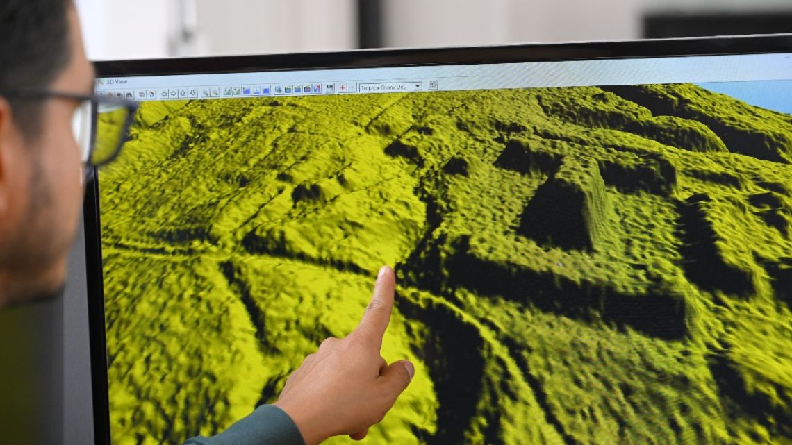
The INPC in 2015 started mapping out the area using LiDAR (Light Detection and Ranging) technology, bouncing laser light off buildings or trees to measure landscapes.
The data was shared with archeologists in 2021.
Last year, Sánchez and Argentine researcher Rita Álvarez presented their analysis of the images in an INPC publication.
Then in January, a French-led team reported their own findings based on the mapping data in the journal Science – giving global news coverage to the discovery.
The site was first described by priest and archeologist Pedro Porras in the 1980s, according to the private Catholic University's Weilbauer-Porras museum in Quito, which displays finely decorated red-tinted vessels, and a piece of volcanic rock carved in a half-human, half-animal shape.
It also houses maps and black-and-white photographs of Porras pointing to the mounds protruding from the ground.
According to researchers who have studied the city network since the 1980s, the Upano people who built it had the political, economic, and religious organisation typical of great civilizations.
Construction on the mounds is thought to have begun between 500 BC and 300-600 AD – around the time of the Roman empire.
Other urban sites discovered in the Amazon date from between 500 to 1,500 AD.
And while Ecuador may once have "envied" the archeological riches of other Latin American nations, the Upano site matches them in "quantity, grandeur, history and cultural expression," archaeologist Alden Yépez of the Catholic University told AFP.
He believes discoveries so far are only "the tip of the iceberg" of an even bigger civilization, and that the site may extend up to 2,000 square km around the Upano, Palora and Pastaza rivers, where there are also signs of settlements.
"The idea that the Amazon was an unpopulated space or only inhabited by nomads has been discarded," said INPC director Catalina Tello.
related news


by Paola López, AFP


Comments